A significant stretch of dangerous heat and humidity is forecast for North Carolina, prompting a WFMY News 2 Weather Impact Alert from the weekend through the middle of next week. After a brief reprieve, the return of oppressive summer weather is expected to bring heat index values well above 100 degrees and potentially hazardous outdoor conditions.
Heat and Humidity Build Friday
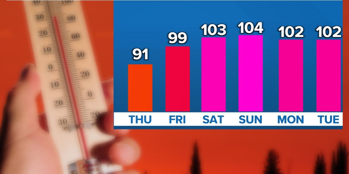
Friday marks the beginning of the transition back to uncomfortable weather as high pressure shifts east, allowing hot and moist air to stream into the region. Afternoon highs across the Triad will reach the low to mid 90s. When combined with rising humidity, heat index values are expected to climb into the 100 to 105 degree range.
Skies will remain mostly sunny, with only a few passing clouds. There is a small chance of an isolated storm, especially southeast of the region, but most areas will stay dry. Dew points will steadily increase into the low to mid 70s by the evening, making it feel especially uncomfortable during the late afternoon and early evening.

Saturday: Peak of the Heat
Saturday will likely be the hottest—and potentially most dangerous—day of the heat wave. Actual temperatures will soar into the mid to upper 90s, and when combined with tropical-like humidity, the heat index will range between 105 and 110 degrees. Some urban areas may feel even hotter.
Conditions will be mostly sunny to partly cloudy, with minimal cloud cover or rain to provide relief. While a stray pop-up storm is possible, the overall atmosphere will be too stable to support widespread thunderstorm activity. Residents should prepare for oppressive outdoor conditions, and a Heat Advisory—or even an Excessive Heat Warning—is likely to be issued.
Sunday: Slight Dip, But Still Dangerous
Sunday’s temperatures will remain dangerously hot, though a notch below Saturday’s extreme levels. Highs will again reach the mid to upper 90s, with heat index values between 102 and 108 degrees. Dew points will remain in the mid 70s, ensuring continued high humidity.
A slightly better chance for isolated thunderstorms is expected during the afternoon or evening. Any storms that do develop may produce heavy rain in a short period of time due to the thick, moisture-laden atmosphere. While localized storms could briefly cool down affected areas, most of the region will remain hot, humid, and largely dry.

Heat Safety Tips
- Limit time outdoors, especially during the hottest part of the day
- Drink plenty of water and avoid alcohol or caffeine
- Take frequent breaks in air-conditioned spaces
- Wear light-colored, breathable clothing
- Check on vulnerable populations, including the elderly, children, and pets
- Never leave children or animals in parked cars
This extended period of heat poses a real health risk. Residents are urged to monitor local forecasts, heed heat alerts, and take precautions to stay safe through the coming days.