After a stretch of sunny days and pleasant evenings, a surge of summer heat is set to return across the region. Here’s a breakdown of what to expect in the coming days, from rising temperatures and heat advisories to the potential for strong thunderstorms.
Thursday: Dangerous Heat and Storm Risk
- Thursday kicks off the next summer heat wave, with a mix of sun, soaring temperatures, and oppressive humidity.
- Expect mostly sunny skies for the first part of the day.
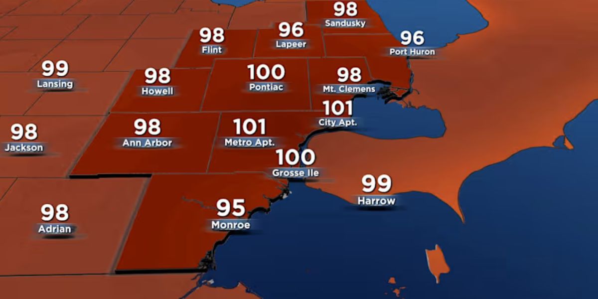
- Highs will climb into the mid-90s, with heat index values reaching or exceeding 100° in many areas.
- A Heat Advisory remains in effect for much of the day due to the combination of high heat and humidity.
- Showers and thunderstorms are likely to develop by late afternoon into Thursday evening.
- The Storm Prediction Center has placed the entire region under a Marginal Risk (Level 1 of 5) for severe weather.
- Primary threats: Damaging winds exceeding 60 mph and heavy rainfall, fueled by high moisture levels and a frontal boundary.
Friday & Saturday: Continued Storm Chances and Slight Cooling
The frontal boundary triggering Thursday’s storms will linger into the weekend, maintaining unsettled weather:
Friday:

- Highs in the upper 80s
- Scattered showers and thunderstorms remain in the forecast
Saturday:
- Slight dip in temperatures, with highs in the mid-80s
- Continued chance of showers and storms
Sunday:
- Clearing Skies and a Warmer Finish
- As the frontal boundary shifts eastward, conditions will improve by Sunday.
- A slight chance of a lingering shower or thunderstorm remains
- Otherwise, skies should clear with highs rebounding into the upper 80s
Early Next Week: More Heat, More Storms
- Temperatures will rise again, potentially reaching the low 90s by Monday
- Another round of showers and thunderstorms is possible late Monday night into early Tuesday
- Highs on Tuesday are expected to return to the upper 80s
- Heat Safety Tips:
With a prolonged period of extreme heat and high humidity on the way, residents are urged to take the following precautions:

- Stay hydrated and limit outdoor activities during peak afternoon hours
- Wear lightweight, light-colored clothing
- Check on vulnerable individuals such as children, the elderly, and pets
- Never leave children or pets in parked vehicles
Stay weather-aware and plan ahead, especially with storms and heat expected to impact daily routines in the days ahead.