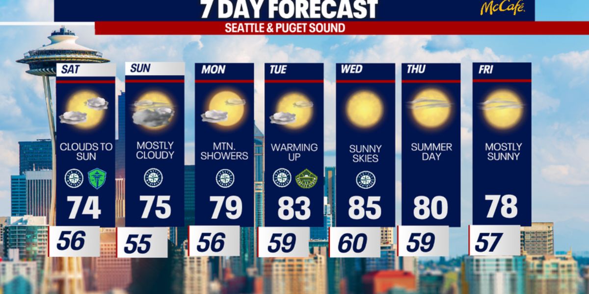
Western Washington saw a noticeable shift in weather today as a weak system brought cooler temperatures and increased cloud cover. After several warm days earlier this week, today marked the coolest afternoon, with most areas experiencing a significant drop in temperatures.
Key Weather Highlights
- Highs dropped to the upper 60s and low 70s
- Temperatures were 10 to 20 degrees cooler than on Thursday
- Increased cloud cover through the weekend
- Chance of showers early next week
Today’s highs only reached the upper 60s to low 70s across the region—down from the mid-80s observed on Thursday. This cool-down was driven by a passing weak system and ongoing onshore flow, which helped maintain overcast skies and suppress daytime heating.
Weekend Outlook
Clouds are expected to increase again overnight, with lows dipping into the mid to low 50s. The onshore flow will persist into the weekend, keeping morning clouds in the forecast with occasional sunbreaks by the afternoon. Despite a few brighter moments, temperatures will remain cooler than average, with highs on Saturday staying in the low to mid-70s.

By Sunday, cloud cover will thicken slightly, continuing the mild and gray trend. A weak front is expected to move through on Monday, bringing an increased chance for light showers and possibly a rumble of thunder, primarily in the Cascade region.
Looking Ahead
Warmer temperatures and sunnier conditions are expected to return by midweek, signaling a gradual transition back to summer-like weather.
Residents are advised to keep light layers handy for cooler mornings and to check local forecasts for any early-week rain developments.